Race to the finish

IMG_0591
Trainers come from miles around to use Langton Wold Gallops
IMG_0562
Gallops manager Andy Bennison inspects the quality of the all-weather track surface

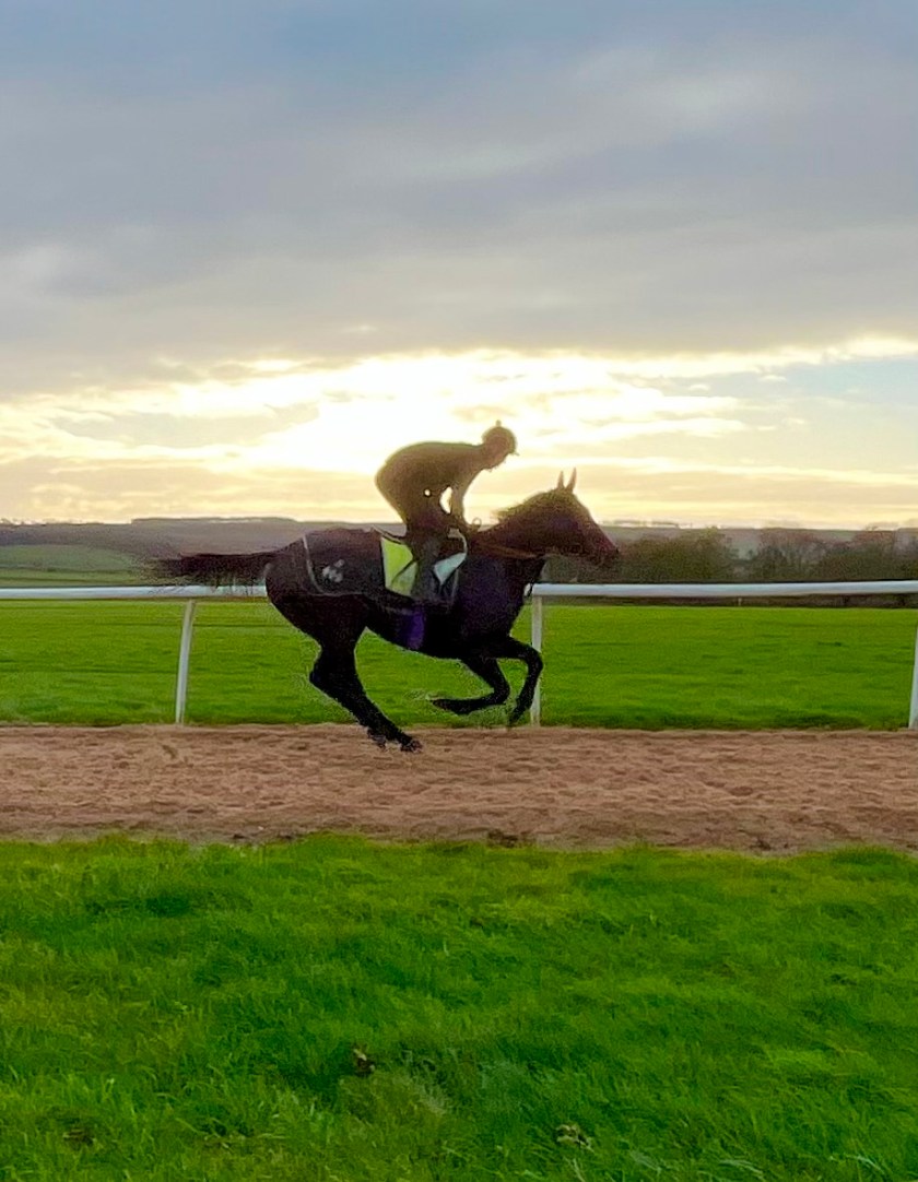
A couple of weeks ago, I had the pleasure of having a tour around Langton Wold Gallops, a facility used by racehorse trainers who come from miles around to use it. Run by manager Andy Bennison, the 200-acre site sits atop a hill on the Langton Road, about three miles south of Malton on the edge of the Yorkshire Wolds.

Andy was asked to help turn the place around by trainers Nigel Tinkler, Brian Ellison and Steve Brown, who as a committee lease the land from the Langton Estate. The gallops were in a bad way, mainly due to lack of funding. Since Andy took over, the committee have invested significantly to create a facility that is unrivalled locally. He has developed six-furlong and 10-furlong all-weather tracks, as well as grass gallops, both on the flat and uphill. There are starting gates to acclimatise young mounts to the sensation of being in the gates, as well fences and hurdles of various widths and heights. Horses who are at the start of their training journey have a special enclosed narrow strip of track with a few hurdles which encourages them to jump the obstacles in front of them rather than run around them.

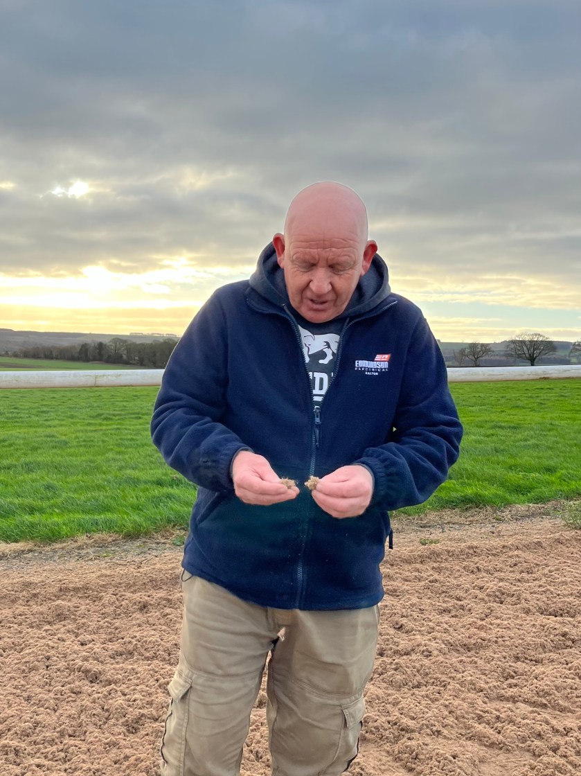
We joined Andy at 9am, but he had already been there for several hours as patrons had been arriving since daybreak. Trailers queued up for their turn and some had travelled from as far away as Darlington for a chance to train on the best ground available. Andy explained how much works goes in to maintaining it, and it is evident that he is passionate, and deservedly proud, about what he does. In the summer, the grass grows so quickly that as soon as he finishes cutting, he has to start at the beginning all over again ‘like the Forth Road Bridge’ he says. Thankfully he has the help of his young assistant Tom, and it is clear that they are both supremely dedicated to what they do, demonstrated by the fact that if it snows overnight, they sleep on-site, each taking two-hour shifts to constantly clear the tracks so that everything is ready for when the jockeys start arriving the following morning. It’s the kind of commitment that is born out of love for the job.

Malton has been associated with horse racing for centuries, with meetings recorded as far back as 1686, although they likely occurred even before then. Under Puritan ruler Oliver Cromwell, the belief had been that the harder you worked, the closer you were to God. Anything deemed fun would lead you to the Devil and thus all sport and entertainment, such as horse racing and gambling, had been banned. But by the mid-1650s, the population had grown tired of Crowell’s strict rules, and by his death in 1658, he was a figure of hate. The monarchy was restored under Charles II in 1660 and, liberated from the shackles of Puritanism, the ‘sport of kings’ boomed.

By 1692, the official Malton Racecourse was on common land just across the road from the current Langton Wold Gallops, and trainers and horse breeders began to congregate around the town, sealing its reputation as a hub of the sport. Owners and enthusiasts descended from all over the country and hotels like the Talbot Inn were bursting at the seams with the racing elite. Such was Langton Wold’s reputation that in 1747, King George III offered 100 guineas in prize money, around. £20,000 today.

The town’s racing scene peaked in the mid-1800s, and more visitors than ever were arriving, thanks to the extension of the railway network. But disaster struck in 1862. To the horror of the racing community, the beloved Langton Wold track was ploughed up after it was sold to a private buyer under the Enclosure Acts, a series of Acts of Parliament between 1604 and 1914 that chopped up and enclosed vast swathes of common land. Racing in Malton never properly recovered, even though a track was briefly set up at Orchard Fields (1867-1870) then later at HighField House (1882-1903).

Although the town has not seen racing for more than 100 years, it is still home to several successful yards and studs. And with its prestigious history in mind, it is a joy to see the name of Langton Wold thriving once again under the expert stewardship of Andy Bennison.

Contact me via my webpage at countrymansdaughter.com. Follow me on Twitter @countrymansdaug.

This column appeared in the Darlington & Stockton Times on Friday 15th and the Ryedale Gazette and Herald on Wednesday 13th December 2023.

A race to find the answer

IMG_8558
The Gysepy Race is clearly visible in the village of Duggleby on the Yorkshire Wolds
IMG_8565
Travel a little further east of the village, and it is barely visible at all

In one of my columns about the Yorkshire Wolds I wondered where the ancient inhabitants of Thixendale sourced their water. There has been evidence of activity in the area since the Mesolithic and the Neolithic periods (Middle Stone Age, 7,000-10,000 years ago and New Stone Age, 5,000-7,000 years ago) as shown by the discovery of man-made tools found in barrows, or burial mounds, dotted about the landscape. Settlements, for obvious reasons, grew up around sources of water, and yet Thixendale lies in a dry valley.

A reader got in touch to suggest that the Gypsey Race might flow through there. When I heard that, the question that immediately entered my head was ‘What on earth is the Gypsey Race?’

As I now know, the Gypsey Race is a natural watercourse that has its source a little east of Wharram-le-Street on the Yorkshire Wolds, passing through villages such as Duggleby, West Lutton, Foxholes, and Burton Fleming, ending where it enters the North Sea at Bridlington. Thixendale lies west of the source, and therefore the river cannot possibly flow through there.

What is peculiar about this particular river, though, is that it flows both above and below ground, and for much of its journey is quite invisible. The word ‘gypsey’ is an East Yorkshire term that refers to a waterway that comes and goes. If the weather remains dry, then parts of the waterway above ground will remain dry, whereas during a period of wet weather, it fills up and flows above ground. What is happening in reality is that the water table is rising and falling, depending on the level of rainfall, and in dry conditions, it simply falls below the level of the stream bed, rendering it invisible to us land dwellers. However, it will still be held in the aquifer below our feet where we cannot see it. If you watch the river closely, you might see bubbles bobbing up to the surface. These are little pockets of air being pushed out from the chalky layer below.

There are such rivers in other parts of the country, with each region having its own term. In some areas, they are known as ‘winterbourne rivers’, the word ‘winter’ referring to the time of year it is most likely to flow above ground, and the word ‘burna’ being an old term for a stream. Places with ‘Winterbourne’ in their name occur where we find chalky ground, mainly on the eastern side of the country. In Kent, they are known as ‘nailbourne rivers’ and in Hampshire they are called ‘lavants’.

There is some folklore around gypsey rivers, the most common being that when it is in spate, it is a portent of doom. It is only relatively recently that we have begun to understand the scientific reasons behind its quirky behaviour and in previous centuries, it baffled and unsettled many, as described in this 1911 quote from ‘Examples of Printed Folk-lore concerning the East Riding of Yorkshire’, edited by a woman known simply as ‘Mrs Gutch’.

‘To solve the mystery of the “Gypsey Race,” as the strange waters are called, has been the ambition of many modern scientists. Little, however, has yet been discovered to account for its eccentricities. Almost as suddenly as they came, some six weeks ago, the waters will shortly disappear, and may not be seen again for years. Only five or six times during the last twenty-one years has this brook run its eerie course. Its source of origin is a hidden mystery. The strange workings of Nature, however, appeal to the curiosity and imagination of the Yorkshire wold-dweller.

‘Day by day young and old watch the stream running its twenty-mile course of hide and seek among the chalk to the sea at Bridlington. Astonishment is often mingled with awe, for according to tradition dire disasters follow in the wake of the brook, and which in consequence bears the sinister title of ” The waters of woe.” Superstitions die hard, and in these out-of-the-way wolds people are still to be found whom it is difficult to dissuade that the running of a stream fed by an intermittent spring is not in some way associated with the supernatural.’

Advances in science mean we now understand why the Gypsey Race behaves as it does. And yet the question remains – where did the ancient residents of Thixendale get their water?

Read more at countrymansdaughter.com. Follow me on Twitter @countrymansdaug

This column appeared in the Darlington and Stockton Times on 1st Septembrt and Ryedale Gazette and Herald on 30th August 2023

Where there’s water

IMG_7171
There has been human activity around the village of Thixendale since prehistoric times

I mentioned the lovely village of Thixendale in my recent column about the Yorkshire Wolds. I had already decided that I would do another piece focussing on that specific village because it has such a rich history. As I was researching, I also came across the mention of the ancient ridge and furrow method of farming, which was also the subject of an earlier column. I’ll have to get back on to those rolling Wolds to see if I can spot the signs for myself!

There has been evidence of activity around the village since the Mesolithic and the Neolithic periods (Middle Stone Age, 7,000-10,000 years ago and New Stone Age, 5,000-7,000 years ago) as shown by the discovery of man-made prehistoric tools such as flints (a sharp stone blade) and scrapers for animal skins. Much of the Stone Age coincided with the Pleistocene Epoch (the last era of the various Ice Ages), and as a result of the frozen ground, early humans lived a nomadic lifestyle, only staying in Thixendale for part of the year until they were driven on by the continuous search for food. The hunter-gatherer diet would have been mainly meat and foraged berries and seeds

It is the two-million-year-long Pleistocene Epoch that is responsible for the topography of the  landscape we see today. The valley in which Thixendale sits would have been created by the run-off from glaciers creating channels though the chalky surface at the end of the Ice Age. The dramatic fluctuations in climate, from greenhouse-hot to freezer-cold, led to the extinction of many large mammals such as mammoths, sabre-toothed cats and giant ground-sloths. This mass-extinction event marked the end of the Pleistocene Epoch and the beginning of the Holocene Epoch which is where we are today.

The advent of the Bronze Age (about 2,500-800BC) led humans to becoming more settled, when the development of stronger and more sophisticated metal tools enabled people to cultivate the land. There have been a number of Bronze Age barrows (burial mounds) found around Thixendale and nearby dales containing bones and ashes of long-dead inhabitants, alongside food vessels, arrowheads and tools. As time went on, these settled areas became more civilised, and a thriving community established itself in and around Thixendale. We know, from excavations at the nearby deserted mediaeval village of Wharram Percy, that there were formal houses built from around 100BC onwards. Many of the routes and tracks linking the various settlements were forged during the Roman period (from AD43 to 410AD) and more established townships evolved from the 10th century onwards. From the air, evidence of the medieval ridge and furrow agriculture can still be seen, which is where individuals owned several strips of land which they would cultivate to grow vegetable and cereals.

The Enclosure Acts (a series of Acts of Parliament starting in the early 17th century that chopped up and enclosed vast swathes of land that used to be common) put an end to much of that, and most of the land was grabbed by the nearby abbeys of St Mary’s in York, and Kirkham Priory a few miles away. They turned much of the land over to sheep grazing, leaving the residents with very little to live on, and it ultimately led to the desertion of some villages, including Wharram Percy. Thixendale would likely have met the same fate had it not been for good old Henry VIII destroying the Catholic monasteries, nabbing the land and then selling it off to the local aristocracy. The Sykes family of the Sledmere Estate bought the village and the surrounding land and established several thriving farms. In the 19th century, Sir Tatton Sykes did much to improve the lot of Thixendale residents, including providing jobs on the various farms, building a school and a also church, which saved the villagers a strenuous four-mile trek to the one at Wharram Percy.

For obvious reasons, settlements establish themselves around a natural source of water for the simple reason that humans cannot survive without it. However, what intrigues me is the fact I’m not aware of a natural water source in Thixendale. As I mentioned in my last column about the Wolds, the valleys in the area are dry due to the well-draining chalky soil.

How did the people of Thixendale get their water in the very beginning I wonder? I’m sure there is someone out there who will enlighten me.

Read more at countrymansdaughter.com. Follow me on Twitter @countrymansdaug

This column appeared in the Darlington and Stockton Times on 4th and Ryedale Gazette and Herald on 2nd August 2023

A wold of difference

IMG_7563
The Yorkshire Wolds seem to play bridesmaid to the more popular Moors and Dales.
IMG_7176
The sweeping valleys of the Yorkshire Wolds were created by the run-off from glaciers.
IMG_7558
The dales have smooth steep sides, but are completely dry due to the quick-draining chalky soil

I have said this before, but I’m not going to apologise for repeating that here in North Yorkshire we are blessed to have outstanding countryside on our doorstep. When you hear visitors from more urbanised areas eulogising about it, it does make you grateful to be able to experience it every day.

What is so special is that within our border, we have two national parks in the Yorkshire Dales and the North York Moors, as well as two areas of outstanding natural beauty (AONB) in the Howardian Hills and Nidderdale.

But what I want to know is why do the Yorkshire Wolds seem to play bridesmaid the two brides of the Moors and Dales? I’ve recently been spending a bit more time exploring this part of the world and in my opinion, it is equally as stunning, and yet very different, to other parts of North Yorkshire.

Famously, artist David Hockney has a studio in Bridlington where he has worked on some enormous pieces of Wolds-themed art. He describes painting in the winter near Warter, a village between Pocklington and Driffield:

“There was far more colour than I expected. Occasionally a farmer would come and talk to me. They didn’t think I exaggerated the colour. They thought my paintings were very accurate, and talking to them I noticed that they knew just how beautiful it is here.”

Of course, North Yorkshire cannot lay claim to all of the Wolds, much of which do lie in the East Riding, but the part I was visiting recently was around the gorgeous village of Thixendale and the abandoned mediaeval settlement of Wharram Percy, all of which falls within the border of our county. The landscape is markedly different to the areas with which I am familiar, with no heather or bracken cloaking the gently undulating hills and dales, but rather crops and grazing meadows, which give you a clue to the type of agriculture that prevails.

The word ‘wold’ derives from the old German word ‘wald’, and originally referred to forested land, later coming to mean ‘upland forest’ then, once the forest had disappeared, grew simply to refer to upland areas in general. The Yorkshire Wolds are the most northerly chalk hills in the UK, and stretch from the bank of the River Humber near Hessle, curving north and east in a wide boomerang shape, ending up at the stretch of coast between Filey and Bridlington. The characteristics of the geology can clearly be seen in the sheer white cliffs at places like Flamborough Head and Bempton.

The chalky nature of the ground is evident as you trek among the rolling hills, with white pebbles scattered across the earth like never-melting hailstones. What truly sets this apart from other areas of North Yorkshire is the appearance of the dales. The steep-sided green valleys slice acutely into the landscape, barely visible from the tops of the hills. The sides are so smooth and neat that they look almost man-made, as if they’ve been cut by a giant cake slice. Unusually, the valleys have no rivers or streams running through them. The chalk was formed from marine limestone and deposited during the Upper Cretaceous period between 80 – 100 million years ago, with the dales being formed at the end of the ice age, around 18,000 years ago, when melting glaciers led to fast-flowing streams coursing across frozen ground, ultimately creating deep channels in the surface of the land. The chalky ground meant water easily drained away, and so the resulting valleys that we see today remain dry.

In contrast to the Moors and Dales, the way the land is farmed is topsy-turvy, with crops like oil-seed rape, wheat and barley being grown across the tops of the hills, while sheep and cattle graze the valleys.

There is plenty of evidence that the land has been occupied since prehistoric times, and perhaps one of the most famous and impressive locations is that of Wharram Percy, a settlement that at its peak in the 14th century was home to around 200 people spread across 40 or so dwellings, including a number of Viking-style longhouses, the footprints of which can still be seen on the ground.

There is an application ongoing for the Yorkshire Wolds to be declared an Area of Outstanding Natural Beauty, and I do hope they achieve it. Having walked there a few times now, they surely deserve that accolade.

Read more at countrymansdaughter.com. Follow me on Twitter @countrymansdaug

This column appeared in the Darlington and Stockton Times on 28th July and Ryedale Gazette and Herald on 26th July 2023