Romans go underground

IMG_2051
Images of the complete Cawthorne Camp near Pickering which comprises four elements which are (L-R) Fort D, Camp C, Fort A and Annexe B. Photo by Tony Hunt of Yorkshire Archaeological Aerial Mapping
IMG_2050
Fort D (left) whose boundary overlaps Camp C (right) which shows it was built later. Three clavicula gates can clearly be seen to the eastern boundary of Camp C. Pictures by Tony Hunt of Yorkshire Archaeological Aerial Mapping.

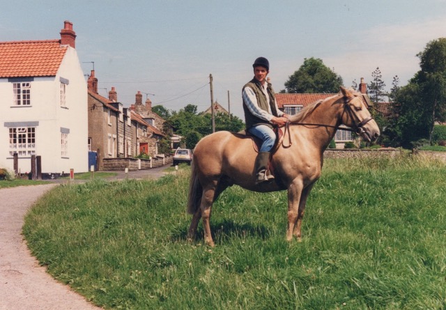
I studied Greek and Roman history at university and am fascinated by the ancient world and the remnants of the past that lie beneath the ground we walk upon today.

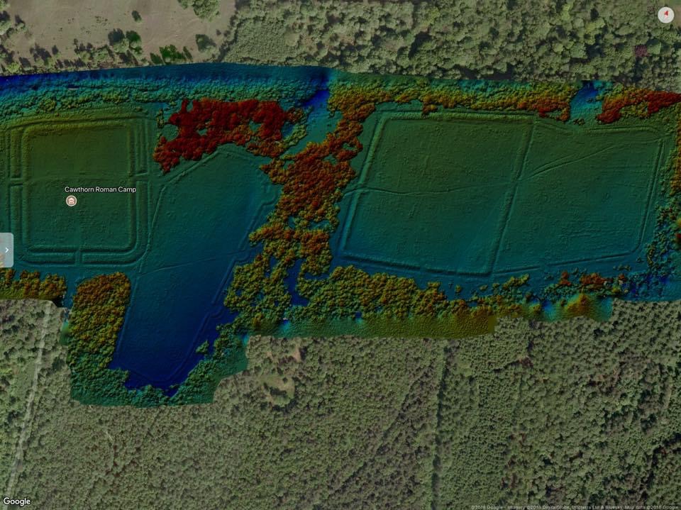
That’s why I was captivated by some pictures of Cawthorn Roman Camp taken from the air by Tony Hunt of Yorkshire Archaeological Aerial Mapping (YAAM) that popped up on Facebook. The specialist imaging revealed the camp in far more detail than can be seen with the naked eye, bringing it to life in a way I had not yet experienced.

Cawthorn Camp lies atop a rocky escarpment a few miles north of Pickering. I’ve mentioned it before in relation to Wade’s Causeway, sometimes referred to as the Roman Road, which runs across Wheeldale Moor from Goathland. Although only a short section is visible now, some believe it linked Whitby with a settlement at Amotherby near Malton, passing through Cawthorn Camp en route. Some archaeologists suggest it is much later and of mediaeval construction, while others think it dates from even earlier than the Romans, and attribute it to the Neolithic or Bronze ages. My theory is based on logic rather than expertise: perhaps the first moor-dwellers forged what they thought was the easiest route across the landscape, and then the Romans came along and rather than go to the trouble of digging out a whole new road across tricky unfamiliar terrain, used what was already there to create a more formal and recognisable highway. Then in the mediaeval period, more features were added. Thus, this mishmash of eras and styles has led to historians arguing as to which period the road officially belongs.

The camp dates from around AD75, although is believed to have been abandoned, re-inhabited, rebuilt and expanded several times over its lifetime. Although finds such as coins, tools and pots peter out after AD120, the camp would likely have been occupied after this date, possibly as a training ground, especially as the Romans occupied Britain until the start of the 5th century. We don’t really know why there are so few finds later than AD120 though.

There are four distinct elements across two separate plots, referred to as Fort A, Annexe B, Camp C and Fort D with A and B adjacent to each other at the eastern end, while C and D are a slight distance away towards the west. On the ground, although you get an idea of its scale through the deep ditches and mounds it is only through aerial photography that you can truly appreciate it. The forts, as the name suggests, will have been more permanent structures, with a building at their centre and ramparts surrounding them. The temporary camps will have served a more transient population of marching infantry. Similar settlements can be found along the routes of many of our Roman roads lying around 25 miles apart, the distance a cohort of soldiers would be expected to march in a single day.

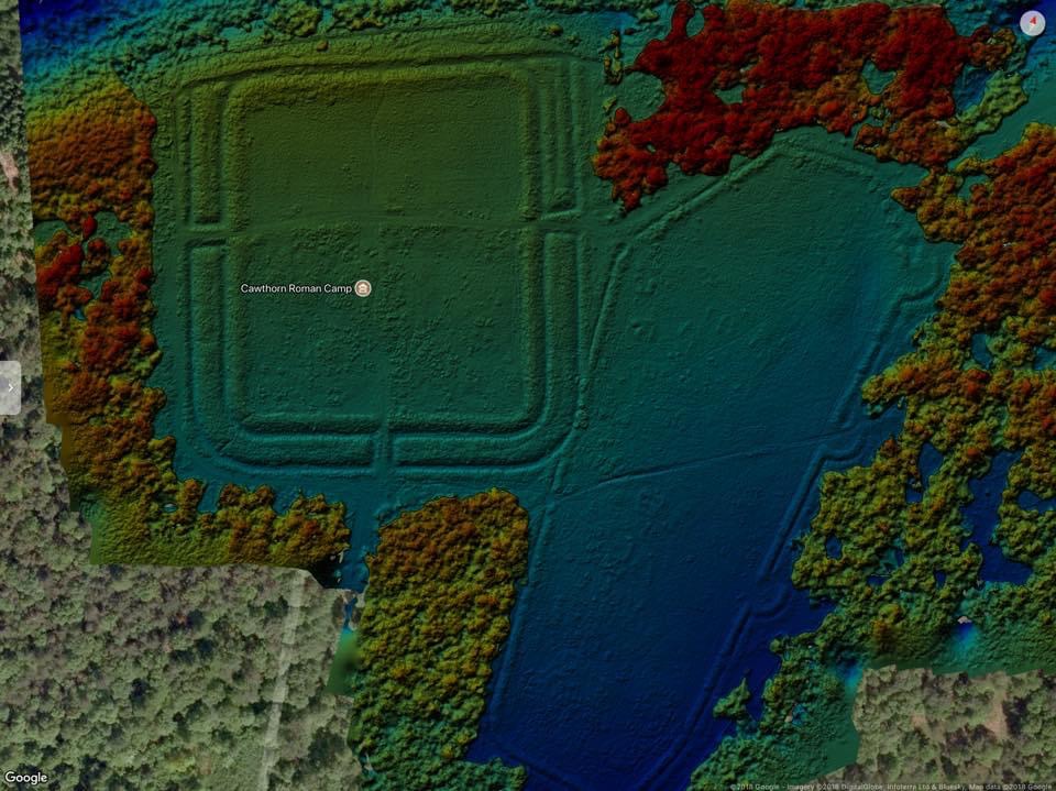
Three of the plots are shaped like rounded-cornered rectangles, with gates facing every direction. We know Fort D was built later than its immediate neighbour, Camp C, thanks to the fact its boundary overlays that of Camp C, as seen in the accompanying YAAM image. Camp C is a bit of a rarity, shaped as it is like a coffin, and instead of having gates on every side as you’d expect, has three large portals along its eastern boundary. There is also one small opening on the western side, but no entrances to the north and south, which is very unusual.

The canny Romans knew a thing or two about building fortifications, and the three gateways (which are clearly visible in the YAAM image on the right side of Camp C), are known as Claviculae (vine tendrils), their curved shape meaning you cannot see in from the outside. The narrowing entrance would force any attacking enemies to shimmy through, trailing their cumbersome shields behind them as they tried to see where they were going with their sword arms before them, vulnerable and exposed, which allowed the defending Romans to easily disable them.

If space permitted, I could go on and on about Cawthorn Camp but I urge you to go and visit. There is still one question though; how much more lies beneath our feet that has yet to be discovered?

I’d love to hear from you about your stories, memories, opinions and ideas for columns. Use the ‘Contact’ button on the top right of this page to get in touch.

This column appeared in the Darlington & Stockton Times on Friday 11th and the Ryedale Gazette and Herald on Wednesday 9th Oct 2024

Pondering on the past

3B2F82BC-3419-46EC-8255-B0DE005F2E98_1_105_c
Reader Paul Ireson on one of his horses in Newton-on-Rawcliffe in about 1987. He owned and named Old Pond House which can be seen with the red door near the car behind him. A carved witch post stands still in tact in the sitting room of the house.

Following my columns about festive birthdays, I have been contacted by one of the few people who declares to enjoy them.

Andrea Dandy says: “I was born on Christmas Day in 1941 and have loved every birthday. When I was a child my brother would complain I always got more presents than him. He didn’t realize I never got any presents during the year. When I had three sons, they also always said I got a lot of presents at Christmas. I also have a nephew who was born on my 27th birthday.”

It sounds like Andrea was quite fortunate, with her loved ones making sure she had enough gifts to cover both Christmas and her birthday, contrary to the experiences of other readers who felt hard done by.

I get a bit of a thrill when readers find articles that I wrote a while back and come to me with new information.

Paul Ireson got in touch about a couple of columns I wrote in January 2023 concerning witch posts. If you remember, these carved posts are usually found near fireplaces in very old houses and originally it was thought that the carvings, often featuring crosses, were intended to ward off evil spirits and witches, hence the name. But over the years, my dad came to believe they were in fact associated with the legendary Martyr of the North York Moors, Father Nicholas Postgate, at a time when Catholics were being persecuted. Dad discovered that posts bearing these cross symbols only proliferated during the time of the martyr, and only in areas he is thought to have visited, which is the main reason why he believed they were connected to Postgate. Their purpose, he suggested, was to secretly indicate to fellow Catholics that they were in a safe house. It is possible that the association with witches was a deliberate ploy by Catholics to spread misinformation so that the true meaning behind the symbols would not be discovered. One of these posts can be seen in the Ryedale Folk Museum in Hutton-le-Hole today.

In one of the columns, I mentioned a 17th century cottage called Old Pond House which has a witch post in its living room. Paul revealed: “I bought Old Pond House in Newton-on-Rawcliffe (near Pickering) in 1986 for £38,000 including stables and a three-acre field. We lived there for several years. I had never heard of a witch post and occasionally people would look through the window and enquire about the post. I revisited Newton recently as I now live at Rosedale but didn’t get a chance to visit the house.”

Paul remembered that when he lived in Newton, there was a dairy farm and a post office-cum-shop in the village, but they have been converted into holiday rentals. He added that their house didn’t have a name and they’d wanted to call it ‘Pond House’. Unfortunately, that name had already been taken by a neighbouring property and so, as their cottage was older, they chose ‘Old Pond House’ instead! He said: “The witch post was in original condition and was always a talking point with visitors.

“At the time I was working in a shop and my wife was a receptionist which shows how affordable property was then. Mind you the mortgage rate was about 12%!…We lived there for four years and had two horses…We travelled to York to work every day in an old Volvo estate that did about 20 miles to the gallon. I recall a few bad winters when we would all wait for the snow plough to come up from Pickering before we could get to work.”

It makes me wonder whether people would go to that effort these days. Not only is the road as far as Pickering (where you pick up the main road) single track, and therefore not easy to navigate in wintry conditions, but it is also a good 35 miles into York. I do remember that, living in a village 20 miles from school, we would go to extraordinary lengths to get there, and very rarely did we look out of the window and decide it was too snowy to set out. These days, it seems, a few flakes come down and the whole of Britain grinds to a halt! But then, we were a hardy lot back then, weren’t we.

Or were we just foolhardy?

This column appeared in the Darlington & Stockton Times on Friday 8th March and the Ryedale Gazette and Herald on Wednesday 6th March 2024.