New homes lead to cross words

Beryl Richardson’s father Bob Carter, left, inspects the stone on Seymour Hill Loftus, which became the trouble-hit Westfield Estate. Reverend John Theobald is on the right, with a Mr Colari from Cleveland Museums in the middle.

Last week when I wrote about a mystery carved stone I had found on a regular walking route, I mentioned Beryl Richardson who comes from Skelton-in-Cleveland. She had a theory about my stone: “The measurements suggest it could be part of an ancient gate post or boundary marker. Some similar to this are on the North York Moors and relate to the boundaries between landowners’ estates.”

She mentioned that her late father, Bob Carter, who came from Loftus, spent many days looking for these boundary stones which he then included in local history talks.

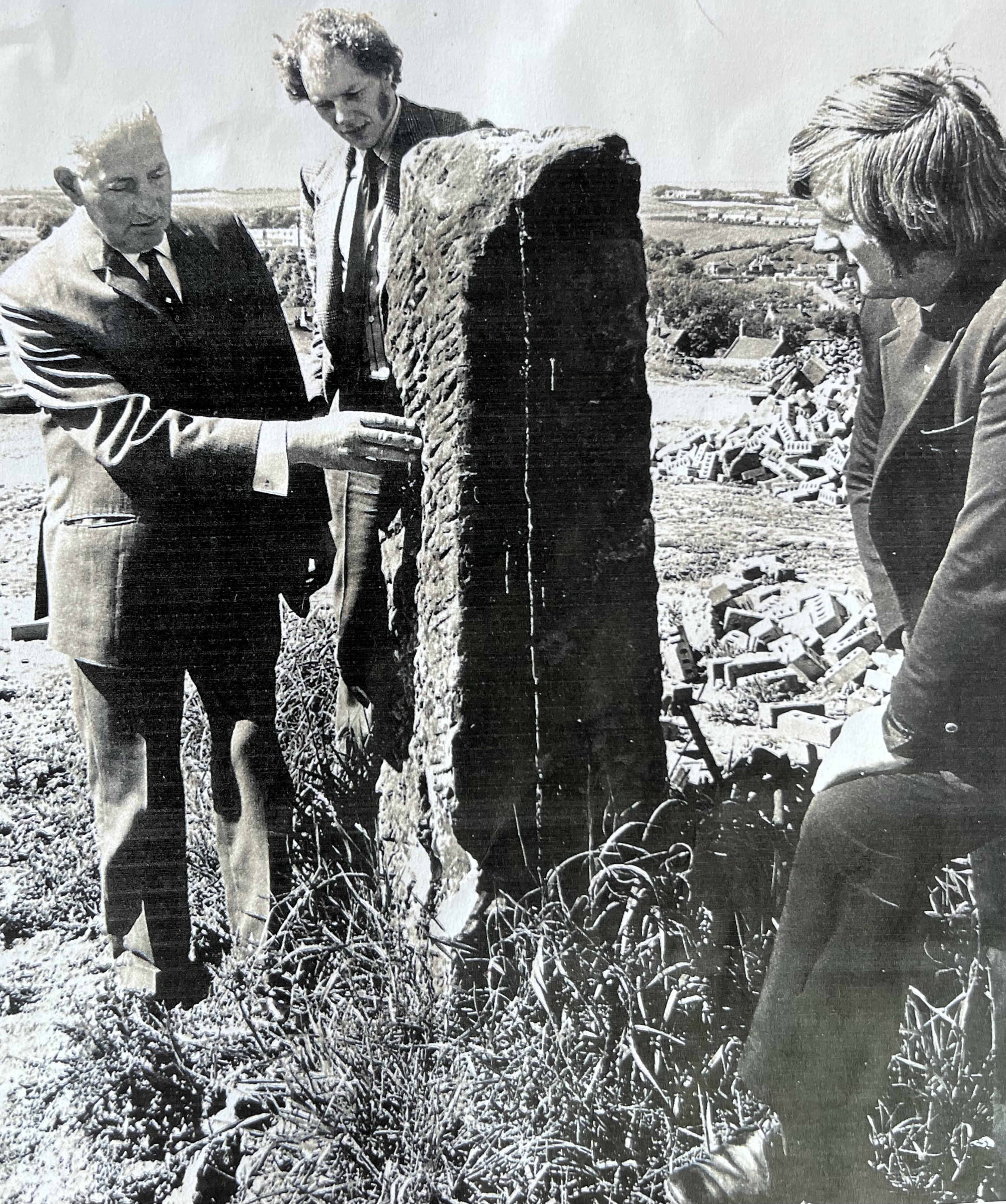
Since then, Beryl has sent me a copy of a photograph, seen here, of her father and a similar carved stone with a mystery attached to it, which makes another interesting-stone related story that readers might be able to flesh out for me.

Beryl is not sure of the exact date of the photo which shows her father Bob, who is touching the stone, alongside a Mr Colari from Cleveland Museums (middle) and on the right, the Reverand John Theobald, Rector of Loftus.

She explains that her father believed this stone to have originally been a cross because it showed traces of a type of lime mortar which would have been used to fix the cross head in place. However, that had long gone. “The old stone cross on Seymour Hill, Loftus, was shown on an Ordnance Survey map from 1858 and was destroyed when building the Westfield Estate in 1974. My father believed the stone marked a burial site,” says Beryl. Her father asked the authorities concerned to open up the site before any houses were built so that they could inspect it for graves, but his pleas fell on deaf ears. Beryl points out that the stone was in direct line of sight towards the Anglo-Saxon burial ground discovered at Street House Farm, three miles northeast of Loftus where 112 graves were found, including that of the ‘Saxon Princess’. It was an incredible archaeological discovery and included artefacts such as gold brooches and pendants and glass beads suggesting royal connections. These finds can now be seen at Kirkleatham Old Hall Museum in Redcar.

Beryl’s old photo must have accompanied a news story about the stone and judging from the piles of bricks and rubble in the background, was taken at the very start of development when the site was being cleared before building work began, which dates it to either late 1973 or early 1974.

The construction of 320 new council houses on Seymour Hill, which became the Westfield Estate, was highly controversial. The development cost the local authority £2.25m (around £21m today) and was dubbed ‘Colditz’ by some of the incoming tenants. The architect came in for a lot of criticism, not only for the general ugliness, but also for not having included back doors in some of the properties, meaning there was no secondary exit should a fire break out blocking the only external door. There were other complaints, such as only being able to hang out washing right outside the lounge window, doors locking automatically leaving children stranded outside, and no central heating upstairs.

In an article from the Middlesbrough Evening Gazette in October 1974 Rev Theobald, who was also a local councillor, described the situation as a ‘tragedy’. “During my calls on my new tenants as Rector of Loftus, people have drawn my attention to a number of factors which point to bad design – all of which are apparent to even the humblest layman,” he said.

I don’t know Loftus well and would welcome any information from people who do, to let me know whether the estate is still there, and if residents still have the same views as they did back in 1974. I do know that it was regenerated about 18 years ago.

It is not uncommon for housing developments to be built on ancient burial sites, but there are rules that developers have to adhere to in terms of respecting human remains and the heritage of any archaeological discovery.

Was the Westfield Estate built on an ancient burial site, as Bob Carter believed? If the local authorities and developers ignored or even destroyed evidence, such as the old cross, were the catalogue of troubles it experienced the ghosts from the past making their displeasure felt?

Do you have opinions, memories or ideas to share with me? Get in touch with me using the ‘Contact’ button on the top right.

This column appeared in the Darlington & Stockton Times on Friday 4th and the Ryedale Gazette and Herald on Wednesday 2nd July  2025

Romans go underground

IMG_2051
Images of the complete Cawthorne Camp near Pickering which comprises four elements which are (L-R) Fort D, Camp C, Fort A and Annexe B. Photo by Tony Hunt of Yorkshire Archaeological Aerial Mapping
IMG_2050
Fort D (left) whose boundary overlaps Camp C (right) which shows it was built later. Three clavicula gates can clearly be seen to the eastern boundary of Camp C. Pictures by Tony Hunt of Yorkshire Archaeological Aerial Mapping.

I studied Greek and Roman history at university and am fascinated by the ancient world and the remnants of the past that lie beneath the ground we walk upon today.

That’s why I was captivated by some pictures of Cawthorn Roman Camp taken from the air by Tony Hunt of Yorkshire Archaeological Aerial Mapping (YAAM) that popped up on Facebook. The specialist imaging revealed the camp in far more detail than can be seen with the naked eye, bringing it to life in a way I had not yet experienced.

Cawthorn Camp lies atop a rocky escarpment a few miles north of Pickering. I’ve mentioned it before in relation to Wade’s Causeway, sometimes referred to as the Roman Road, which runs across Wheeldale Moor from Goathland. Although only a short section is visible now, some believe it linked Whitby with a settlement at Amotherby near Malton, passing through Cawthorn Camp en route. Some archaeologists suggest it is much later and of mediaeval construction, while others think it dates from even earlier than the Romans, and attribute it to the Neolithic or Bronze ages. My theory is based on logic rather than expertise: perhaps the first moor-dwellers forged what they thought was the easiest route across the landscape, and then the Romans came along and rather than go to the trouble of digging out a whole new road across tricky unfamiliar terrain, used what was already there to create a more formal and recognisable highway. Then in the mediaeval period, more features were added. Thus, this mishmash of eras and styles has led to historians arguing as to which period the road officially belongs.

The camp dates from around AD75, although is believed to have been abandoned, re-inhabited, rebuilt and expanded several times over its lifetime. Although finds such as coins, tools and pots peter out after AD120, the camp would likely have been occupied after this date, possibly as a training ground, especially as the Romans occupied Britain until the start of the 5th century. We don’t really know why there are so few finds later than AD120 though.

There are four distinct elements across two separate plots, referred to as Fort A, Annexe B, Camp C and Fort D with A and B adjacent to each other at the eastern end, while C and D are a slight distance away towards the west. On the ground, although you get an idea of its scale through the deep ditches and mounds it is only through aerial photography that you can truly appreciate it. The forts, as the name suggests, will have been more permanent structures, with a building at their centre and ramparts surrounding them. The temporary camps will have served a more transient population of marching infantry. Similar settlements can be found along the routes of many of our Roman roads lying around 25 miles apart, the distance a cohort of soldiers would be expected to march in a single day.

Three of the plots are shaped like rounded-cornered rectangles, with gates facing every direction. We know Fort D was built later than its immediate neighbour, Camp C, thanks to the fact its boundary overlays that of Camp C, as seen in the accompanying YAAM image. Camp C is a bit of a rarity, shaped as it is like a coffin, and instead of having gates on every side as you’d expect, has three large portals along its eastern boundary. There is also one small opening on the western side, but no entrances to the north and south, which is very unusual.

The canny Romans knew a thing or two about building fortifications, and the three gateways (which are clearly visible in the YAAM image on the right side of Camp C), are known as Claviculae (vine tendrils), their curved shape meaning you cannot see in from the outside. The narrowing entrance would force any attacking enemies to shimmy through, trailing their cumbersome shields behind them as they tried to see where they were going with their sword arms before them, vulnerable and exposed, which allowed the defending Romans to easily disable them.

If space permitted, I could go on and on about Cawthorn Camp but I urge you to go and visit. There is still one question though; how much more lies beneath our feet that has yet to be discovered?

I’d love to hear from you about your stories, memories, opinions and ideas for columns. Use the ‘Contact’ button on the top right of this page to get in touch.

This column appeared in the Darlington & Stockton Times on Friday 11th and the Ryedale Gazette and Herald on Wednesday 9th Oct 2024