Water engineering marvel

19th century Thirlmere Aqueduct is the longest gravity-fed aqueduct in the country, ending almost 100 miles away in Manchester

I spent a wonderful weekend with friends in the Lake District recently, staying a cottage near the beautiful Grasmere. It’s a lovely, though very small, village and we took time to visit the graves of the famous Wordsworth family found in St Oswald’s churchyard. We walked around the peaceful shores of the lake and also managed a challenging climb up the short but steep Grey Crag to Alcock Tarn.

On the way down the fell, our route guide told us to look out for Thirlmere Aqueduct, a gravity-fed pipeline built in Victorian times that takes fresh water all the way from Thirlmere Reservoir to the city of Manchester. This reminded me of hydro engineer Joseph Foord whom I wrote about in this column a couple of years ago. In the mid-1700s, Foord came up with a groundbreaking system of channels that used gravity to feed fresh water to remote villages high on the North York Moors.

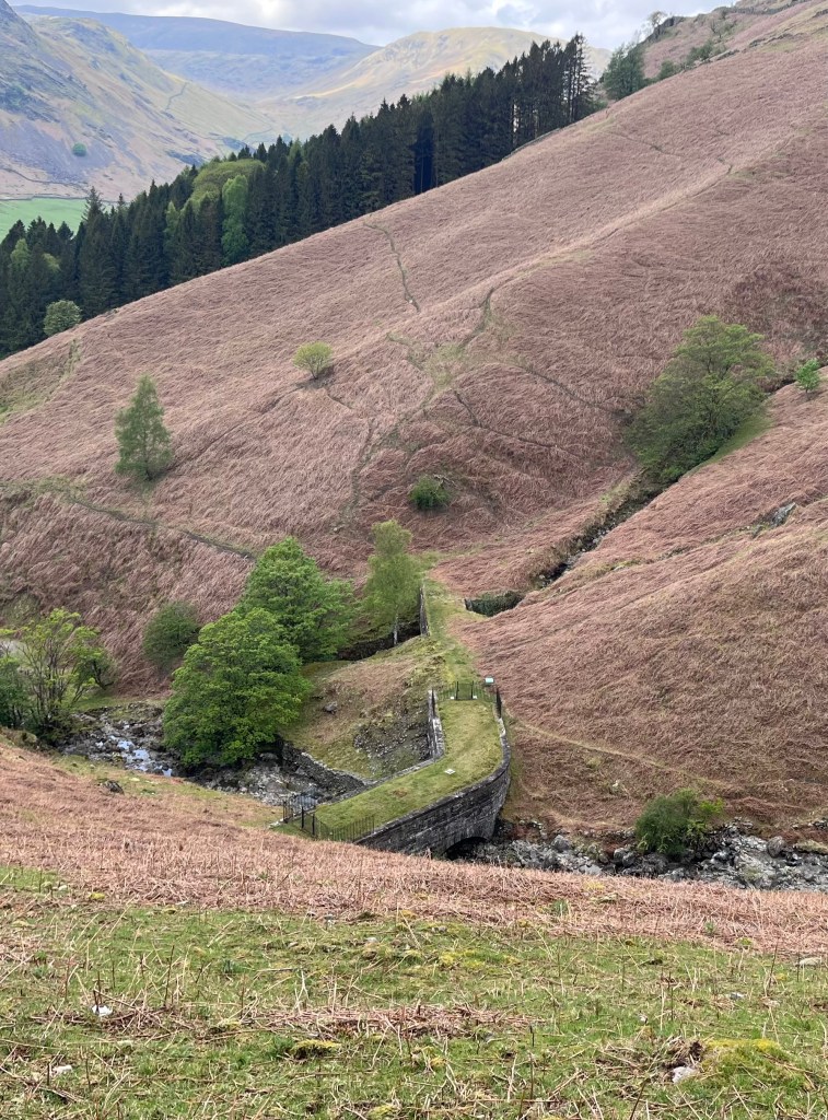
The aqueduct was easy to spot, and took the form of a grass-topped masonry bridge over one of the many streams that tumbled down the hillside. I assumed the stream formed part of the aqueduct, providing plenty of gravity as it raced down the hill, but I was confused about how the system worked. In my head, an aqueduct carries water over or through an obstacle, and upon first sight, this little bridge went over the stream but was not connected to it. Another question was why was it called Thirlmere Aqueduct, when Thirlmere was a good six miles away.

Of course, my column-writing brain kicked immediately into gear, and once I got home, I set about finding out more about this engineering conundrum.

It turns out that what we were looking at was indeed the aqueduct, but the water that was being transported to Manchester was inside the bridge, not running underneath it. The ‘bridge’ was not a bridge at all, but a tunnel.

The aqueduct was the brainchild of engineer John Frederic La Trobe Bateman who was a big name in hydroengineering and established the foundation of today’s British water industry. As the Industrial Revolution took hold, Manchester grew increasingly important as a commercial centre and as a result, the population rapidly grew too. To continue to be successful, the city would need far more water that it was currently getting.

Bateman identified the Lake District as a potential source because it had more far more water than its inhabitants needed, and also plenty of rainfall to ensure a continuous supply. After deliberating over which lake was most suitable, Thirlmere was chosen. There was plenty of opposition from locals understandably wanting to preserve it just as it was. But they were overruled.

I’m a little confused as to the date the ambitious project began, as some online resources suggest it was Queen Victoria who gave the go-ahead in 1890. But I found an obituary published in the year of Bateman’s death (10th June 1889), in which it states work had begun by 1880.

The initial stage involved increasing the size of the lake. Bateman calculated that they had to raise its height by 56 metres to provide the 50 million gallons a day needed, and, which they would achieve by building a dam at one end, and flooding the valley behind it to create a large reservoir.

The next engineering feat was to transport that water across 96 miles and 28 valleys using gravity alone. A series of tunnels totalling around 50 miles were dug out of the rocky hills, some large enough to fit a small car through. The ‘cut and cover’ method was used whereby a ‘D’-shaped trench was dug, lined with brick, and covered with earth. Cast iron pipes were used for the remaining 46 miles and a gentle gradient of 1 in 3000 ensured  a consistent southerly flow of water.

In various places, they had to cross fast-flowing streams tumbling down the fells, some of which ran below the level of the aqueduct. In such cases, the tunnels were constructed within small masonry bridges built over these streams, which is exactly what we saw on our descent from Alcock Tarn.

Thirlmere Aqueduct remains the longest aqueduct in the country, and continues to provide Manchester with its supply using gravity as its main mode of transport.

Those Victorians weren’t half clever.

Do you have opinions, memories or ideas to share with me? Get in touch with me using the ‘Contact’ button on the top right.

This column appeared in the Darlington & Stockton Times on Friday 22nd May and the Ryedale Gazette and Herald on Wednesday 20th May 2026

Flowing up the hill

IMG_9405
The outline of one of Joseph Foord’s water races can still be seen at Newgate Bank on the Helmsley to Stokesley Road

IMG_9419

I was contacted by reader Ted Naisbitt in connection with my columns on how ancient folk living in dry areas managed to get access to drinking water. Reader Jo Bird had suggested that perhaps wells were constructed, and I wondered if prehistoric humans had the engineering know-how to be able to dig deep wells. My research revealed that indeed they did, as evidenced by a sophisticated drainage system that has been discovered at the 4th century BC settlement of Skara Brae in the Orkneys.

Accessing fresh water was a continuous battle for people living in remote communities, and Ted mentioned a hydraulic engineer called Joseph Foord who was active on the North York Moors in the 18th century. He was prompted to find out more after a visit to Thirsk Tourist Information Office (where Ted volunteers) by Coxwold resident Ken Ward who used to live by one of these water channels. Ken was keen to find out about the engineer whom it is said performed ‘miracles’ by making water seemingly run up hills.

“Prior to the 18th century the towns and villages along the southern edge of the Moors (roughly the A170) did not have access to fresh running water,” says Ted, “But just a bit further north on the other side of the tabular hills there was plenty. This engineer managed to bring fresh water to these places by surveying for and digging out narrow ‘canals’ around them often for many miles and overcoming many obstacles on the way. In places an optical illusion made it seem as if the water was running uphill.”

Ted pointed me to an article about Foord on a website called ‘Yorkshiremoors.co.uk’, and I must give credit to that website for what appears in this column, as there doesn’t seem to be a great deal online about him. I will also have a look in my dad’s archives next time I go see my mum as I’d be surprised if he hasn’t written about him. What Foord achieved is highly noteworthy, and he deserves to be remembered.

Joseph was born in 1714 in Fadmoor near Kirkbymoorside into a Society of Friends (Quaker) family and at the age of 20, when his father Matthew passed away, he inherited their farm at Skiplam Grange, along with some mills and shares in mines at Ankness between Fadmoor and Bransdale. 1744 was a momentous year for Foord, as he was also ejected from the Quakers for having fathered an illegitimate child.

Foord became an engineer and a surveyor and, having grown up on the North York Moors, was well aware of the difficulties faced by inhabitants of remote villages on top of these limestone hills. They would have to transport heavy vessels of water over rough terrain and up steep inclines, making an already tough life even more so.

In about 1747, Foord came up with the idea of constructing channels, or ‘races’, to transport water from the springs on the high moors to the dry communities. His first experimental race ran for five miles and supplied Gillamoor and Fadmoor. What was particularly unique, though, was that these two villages sat high on the hills, and the task of getting water up the hill was the problem, or so it seemed.

According to Yorkshiremoors.org: “Gillamoor is about 525ft above sea level. The northern, highest, tip of the tabular hill that contains the village is at Boon Hill, about a mile and a half to the northwest. The ground at the base of Boon Hill is 650ft above sea level, and thus 125 feet higher than Gillamoor. Foord was thus able to construct a water course that could run downhill, while at the same time appearing to climb up the steep slopes below Gillamoor!”

In 1759, the water course was extended to Kirkbymoorside, then ultimately to Carlton, Newton, Pockley, Old Byland and Rievaulx, delivering precious fresh water to the residents. As he was so familiar with the geology and geography of the area, in the end, Foord was able to construct around 70 miles of water courses, some of which are still visible today, such as from Newgate Bank on the A1257 Helmsley to Stokesley road.

Foord died in January 1788 at his daughter Mary’s home in Fawdington near Thirsk. Despite never being welcomed back into the Society of Friends, he was interred as a non-member in their burial ground.

Read more at countrymansdaughter.com. Follow me on Twitter @countrymansdaug.

This column appeared in the Darlington & Stockton Times on Friday 20th and the Ryedale Gazette and Herald on Wednesday 18th October 2023.